

Again, buying a postcard led to me doing a bit of research to satisfy my own curiosity as to some of the story about a part of Auckland. The Chancery Street area has come up time and again, mainly from the 19th century references to it being something of a near-slum area by the 1860s. In the detail above from the 1866 Vercoe and Harding map of Auckland (NZ Map 18, Sir George Grey Special Collections, Auckland Library), the area I looked into is from the second Wesleyan Chapel (left, fronting the corner of High Street and Chancery Street, on Allotment 27 Section 4, City), the Mechanics' Institute building alongside (Allotment 26), William Street through Allotment 25, and "Chancery Lane" through Allotment 24.
This latter accessway between Chancery Street and Victoria Quadrant (Kitchener Street) came to be known as "Bacon's Alley", after William Bacon, proprietor from the 1850s of the Oddfellows Arms Hotel, located at the corner of Chancery Street and the lane which would come to bear his name. Bacon purchased land in the area as early as 1843, but lost it to the Improvement Commissioners in the early 1870s when Auckland City Council took over the area to try to create a road link from Coburg Street (part of Kitchener Street now, south of of Victoria Street West) and Shortland Street.
For the purpose of obtaining such access it will be necessary that a new street should be formed from Victoria Quadrant, in the vicinity of the Wesleyan Chapel into Shortland-street, and thence into Fort-street, near its junction with Commerce-street; and that Victoria street should be extended into Victoria Quadrant, over land the property of Mr Thomas Outhwaite. To effect this it is expedient that lanes and private alleys in the vicinity of Chancery-street should be abolished, and that several houses and huts there should be removed, and that Chancery-street should be widened. The Commissioners by this Act, seek to obtain compulsory powers for the purchase of the estate interest, and rights of all persons in the land and houses required for the formation of such streets and works, and for the abolition of such lanes and private alleys as aforesaid, and for the acquisition of lands and houses adjacent to the same for re-sale by the Commissioners after the new streets have been formed and the old streets widened.
(Star 23 May 1873)
That road link was meant to provide more direct access between the port and the sections being divided up for lease and sale by the Improvement Commissioners (see also my posts of the Drill Hall and Princes Street). But -- it didn't come to pass. The main effect was that the Wesleyan Chapel site, the Mechanics Institute, William and Bacon's Lanes all became property of Auckland City Council, much this remaining in Council hands until the mid 1980s.
But, I'm getting ahead of myself, here ...

Above, the Chancery area c.1857, from the lower slopes of Barrack Hill (Albert Park), in the vicinity of today's Bowen Avenue. The prominent building centre right was the second Wesleyan Chapel fronting High Street. To the right of the chapel, just across an un-named accessway which became Courthouse Lane in the 20th century, the Auckland Mechanic's Institute. The roadway from left to right is Victoria Quadrant (now part of Kitchener Street). Ref 4-864, Sir George Grey Special Collections, Auckland Library.
The original Wesleyan Chapel was wooden, and built 1843 on the same site. In 1846 (New Zealander 28 March), the chapel was enlarged, but in 1848 it was completely replaced by a brick structure (New Zealander 18 October 1848). This sparked off a heritage mystery which still lingers. The Silverdale and Districts Historical Society have a wooden chapel on their museum site which, it is claimed, is the old High Street chapel, after having been relocated to Parnell, and then to the Wade (now Silverdale) in 1860. But original deeds and documentation proving the High-street to Parnell to Wade links have been lost.
According to the New Zealander, 12 May 1849, the chapel was converted by that time into the Wesleyan Day School, adjoining the new chapel. It was still there Christmas Day 1852 (New Zealander). As the Sunday School, it appears to have remained in that position right down to 1874, when the Improvement Commissioners bought the property from the church trustees (Southern Cross, 22 May 1873). I've found one reference to a Wesleyan Chapel at "Wade Bridge" by 1866 (Southern Cross, 3 February) so, I tend to think at this stage that the chapel at Silverdale wasn't from High Street.

The same scene, c.1869. Where this bloke is sitting is now the busy road called Bowen Avenue. Ref 4-3390, Sir George Grey Special Collections, Auckland Library.

Two images stitched together, from the 1860s, showing the view from another vantage point on what is now lower Albert Park. Refs 7-A5474 and 7-A5475, Sir George Grey Special Collections, Auckland Library.

The scene in the early 1870s. Ref 4-8996, Sir George Grey Special Collections, Auckland Library.
In 1875, the Improvement Commissioners proposed to offer the brick chapel to the Mechanics' Institute, in return for the Institute's land so that the connecting road could be pushed through. (Star, 2 September 1875) Nothing came of that, but St Paul's School did use the old Wesleyan schoolroom at the rear of the chapel for a time from 1876. (Southern Cross, 9 June) But the chapel and its site between High Street and Victoria Quadrant was to take on a new role -- that of the Magistrates and Police Courts, and (later) the Land and Deeds office.
A petition, very largely signed by members of the legal profession, Justices of the Peace, and prominent citizens, is about to be presented to the Hon. C. C. Bowen, Minister of Justice, having for its object the shifting of the District Court, Resident Magistrates' Court, and Police Court, to the old Wesleyan Chapel, in High-street ... The Wesleyan Chapel is a large and commodious edifice. By the expenditure of a moderate sum every convenience could be secured. The mere shifting of the Court house would save to the public and the profession in a single year all the costs of the improvements five times multiplied. The Minister of Justice will do well to accede to the prayer of the petition, as a public benefit of no inconsiderable extent will be secured.
Auckland Star 10 April 1876
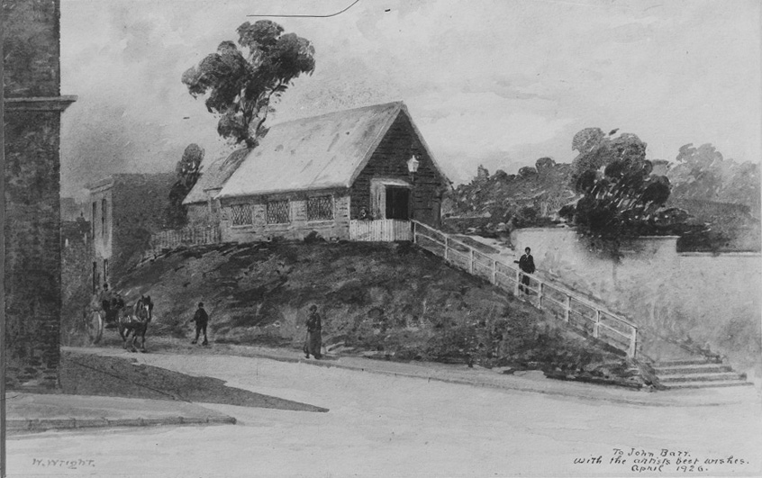
"Watercolour painting by Walter Wright showing the Mechanics Institute
which was situated on the corner of High Street and Chancery Street, the
ramp at the right led to Courthouse Lane." Ref 4-675, Sir George Grey Special Collections, Auckland Library. The lane to the left appears to have been just a blind access lane -- now all part of today's Chancery development.

The Mechanic's Institute, 1880s, probably before conversion briefly as the Auckland Public Library. The beginning of Courthouse Lane can be seen in the foreground, at that point simply a pedestrian access. Ref 4-25, Sir George Grey Special Collections, Auckland Library.
The old Mechanics' Institute, one of the few links between past and present day Auckland, is to be demolished in the course of a week or two, after an existence of over 60 years. The building, a quaint old one, adjoins the Magistrate's Court at the corner of High-street and Chancery-lane, and though for some time past its dignity has been disturbed by the hubbub of the workroom, some 30 or 40 years ago it boasted the name of "The Mechanics' Institute," and for many years the front portion of the building was used as a public hall, where matters of great national import were ofttimes heatedly discussed with all the fire and spirit of the "good old days." The library which was attached to the Institute after a time fell on luckless days, and after futile efforts had been made to interest the Government in its behalf, it was in 1879 offered to the City Council as a free gift to form the nucleus of a public library. The offer was accepted, and in 1880 the Free Public Library came into being, continuing in the old building till 1887, when it was transferred to the present building by virtue of the Costley bequest, and Sir George Grey improved the occasion by donating his splendid collection of books and other treasures to the institution.
Auckland Star 23 September 1909

"Looking from Bowen Ave (right), Victoria Quadrant now Kitchener Street
(left) showing the Northern Club(centre) and Albert Park (right)", 1880s. Ref 4-133, Sir George Grey Special Collections, Auckland Library.

The Chancery area in the 1880s. The former chapel building is now extended, with what appears to be front and rear porches, serving as the district and police court. Ref 4-140, Sir George Grey Special Collections, Auckland Library.

The Chancery district, in Hickson's 1882 map of Auckland (NZ Map 91, Sir George Grey Special Collections). Courthouse Lane has yet to be mapped, but probably existed as an unofficial access past the Mechanics' Institute building. William and Bacon Lane are survivors (although William Bacon's Oddfellows Hotel didn't). Another lane further east, shown in 1866, didn't last.

The Court House in High Street, formerly the Wesleyan Chapel, unknown date. Ref 4-774, Sir George Grey Special Collections, Auckland Library.
In 1880, the Crown took over the former Wesleyan Chapel site as a Residents Magistrate's court and Police court. (Star 16 March 1880) The District Court's sessions opened there 14 March 1881. (Star 21 March) By 1911, the building had become the Land and Deeds office, as the district court moved to the new building fronting Victoria Quadrant.

This is the postcard which attracted my attention to all this: the NZ Express Company's Central Sample Rooms, at the top of Courthouse Lane, fronting Victoria Quadrant, from 1906.


I especially like this detail of two of the company's carts, ready and waiting for service. Courthouse Lane, as can be seen, was quite narrow.

In this detail from a 1909 plan (DP 2789, LINZ records, crown copyright), Courthouse Lane isn't even named. The site of the Central Sample Rooms building is in yellow.
Originally four storeys, the company added two more in 1913 (ACC 213/83k, Auckland Council Archives). The site was leased to NZ Express from 1903 by the Council (NA 113.13) until 1945 when the site was leased to Nagel Creations, manufacturers of lingerie.

Auckland city, viewed from the Grand Hotel, 1910s. Chancery Street is on the right. Photographer unidentified. Reference Number: 1/1-002803-G, Alexander Turnbull Library.
In the above image, Albert Park is to the left, Chancery Street to the right, the Central Sample Rooms just left of centre (and by then built up to 6 storeys), with the Police Court/Deeds Office just to the right of the Sample Rooms, other side of Courthouse Lane.
Then in 1985, Council sold the land first taken over by the Improvement Commissioners more than a century before for a road which was never created. NZI engaged in a massive redevelopment of the area, involving the closing of William (now Warspite) Lane, closing and re-creating Bacons Lane as a broad street to the east, and the demolition of the existing buildings, including the old Central Sample Rooms by 1988-1989.

So, today -- this is Courthouse Lane from lower Albert Park. Left is the former courthouse building (referred to in this post), while to the right is the new building (1990s) in place of the Central Sample Rooms. Oddly, it fills much the same footprint.

Closest I could get to recreating the 1906 postcard's view. There has been much in the way of foliage growth on the hill since then ...

I quite like the new building. A pity the old one is gone, but it had been altered and added to over the years, and was simply the standard Edwardian mercantile style. However this one does indeed look quite smart -- and if you want a nice cuppa and a meal, go to the coffee shop right on the corner there. They cook a wonderful eggs benedict.

This is more or less what Warspite Lane has become -- a set of steps, leading to Chancery Square. All now a far, far cry from the seedy hotels, infamous brothels, grimy streets and places of learning and worship in the edge of the ridge.


Thanks Lisa for this post it's been a fascinating read. It's amazing how the shape of the city changed as time progressed. Loved this post!
ReplyDeleteYou're welcome, Liz.
ReplyDeleteThank you for this great information. My great great grandparents were married in the Wesleyan Chapel in 1857.
ReplyDeleteGlad to be of help, Sally.
ReplyDeleteHave seen photos of Magistrates Court construction in 1910-1911, but haven't been able to find them again. Any ideas for finding them would be appreciated. Worked there for many years. Wonderful images leading up to the existence of the "new" Magistrates Court thanks.
ReplyDeleteMalcolm Webby.
Any photos of workman constructing Magistrates Court in Kitchener Street around 1911.
ReplyDeleteYou could try enquiring at Historic Places Trust?
ReplyDeleteAwesome reading, I used to work in O'Connell Street late 1990's early 2000's. You never know what happened in this area previously, thanks for the great read
ReplyDeleteInteresting read thank you! Have also found this article on the Chancery area which intrigued me because my great great great grandparents were living on Chancery Lane (subsequently Bacons Lane) in the late 1850s / early 1860s......in pretty dire circumstances. Fascinating stuff!
ReplyDeleteThank you, great reading. In Papers Past in 1886 the High court was referred to as the Supreme Court - is this the same as the 1880s Court house in High Street (Magistrates Court) you have pictured? Kind regards Lorraine
ReplyDeleteNo, you're thinking of the Supreme Court at the corner of Waterloo Quadrant and (now) Anzac Ave.
DeleteWhat are the earliest New Zealand photos anything 1830 or under??
ReplyDeleteNope. 1850s, barely.
Delete