Sunday, December 12, 2010

Paparoa: dates on gates


Last weekend, I made a break for it and headed north for a few days with Liz of the Mad Bush Farm blog. While up North, she took me through Paparoa one day. The stop that sparked off the first lot of these photos came about because she spotted scarecrows in a hedge. First thing I spotted, though, were the gates with the dates: 1862 and 1962.

Ah, ha! A centenary. And yes, the accompanying plaque backed that up.


Paparoa's first settlers arrived in the spring of 1862, with the first land sales in December that year. It was termed the "Paparoa Special Settlement." According to a report read to the first meeting of the settlers on 9 October 1863, this was because: "... we are physically separated from the Oruawharo or Albertland, and must exist under a separate local government, and be responsible for our own social arrangements and asdvancement, we decline to adopt the term Albertland. Paparoa forms a settlement, and not a limb of any other settlement." (Albertland Gazette, 2 December 1863)

By October 1863, they were making plans to erect houses of worship, were involved with clearing the namesake stream to make it navigable (but a broken dam didn't help matters), hade been granted a weekly postal service, and even had a collection of books as a library -- although the folks at Oruawharo felt the books were for their own exclusive use, much to the chagrin of the Paparoa settlers.

The gates lead through to the North Kaipara A&P Showgrounds. Still actively used, as can be seen by the sign ...


...but with an interesting neglected look to the structures, due to rampant overgrowth. Almost relics, but not quite, not yet.


Next to the showgrounds, the former Paparoa Bowling Club. Not a bowling club anymore though ,so Liz told me. The club still does exist, but just not there anymore.


Could this be where there was a bit of a to-do at the Paparoa Bowling Club in 1937 over inebriated players?

Mr. E. A. Fenwick at a meeting of the Paparoa Bowling Club alleged that on visiting days there was too much liquor on tap. He said it was getting absolutely over the odds, and they now came to a question of drinking or bowls. He alleged that on one occasion when the club was visiting a neighbouring club two players became incapacitated, as far as bowls were concerned at any rate, in his opinion. The club should drop liquor on visitors' days. The proposal met with a storm of protest, speakers stressing that the club members were temperate, and that the Paparoa Club could not be blamed for the sins of others. The proposal lapsed.
(Evening Post, 22 June 1937)


If so, I don't know how well-lubricated players would have handled this -- the ArtyFarties makeover of the old clubrooms. Complete with a door labelled "Jacks" and another "Kittys".


Where players plonked themselves down in the sun waiting for their turn on the green -- that's taken a multi-coloured turn as well.


And then -- there are the scarecrows.


The Welcome to Paparoa signs are part of a series guiding tourists along their way in the district. I personally think the artwork is cool, even if stylised and a bit liberal with geography.


One feature on the artwork is the former National Bank, now the Sahara restaurant. It isn't doing too bad today, seeing as it dates from 1914.


The other iconic image from the signs' artwork is the Paparoa Store. Websites, usually connected with the Sahara, describe it as "historic", but they are not terribly helpful with details as to how historic. Still, it used to have a petrol bowser in front, one of the rectangular ones Shell Oil ones, as can be seen by the marks still on the concrete, and the metal Shell cap still fixed into the surface.  Plus, it looks very cool. Hopefully someone has a date somewhere. My guess would be around the time the bank was built.

Hurstmere chocolates and butterflies

Photobucket

Hello all. I'm still around, just busy completing some commission projects before a certain annual festival takes hold. I spotted the above (click on the thumbnail for larger view) on the footpath along Hurstmere Road in Takapuna. Cleverly done, thought I -- here's hoping we see more to brighten our dull grey urban existence.

Sunday, November 28, 2010

New Zealand Legal Information Institute

Another reference site, made known by Brian Rudman of the NZ Herald when he made a foray into the morass that is the Auckland Domain's history of land nibbling. Rendell McIntosh from Parnell Heritage gave me a head's up on the site: New Zealand Legal Information Institute.

An unweildly title, to be sure, but -- it allows keyword access to not only current legislation, but historic stuff as well. In doing the Zoo War for example, I'd have found this a blessing, as I was tracking back on acclimitisation and exotic anilmal legislation here.

Wednesday, November 24, 2010

New Zealand's Lost Cases Project

Having a bit of a nosey around the 'Net this morning, I stumbled across the New Zealand Lost Cases database, produced by Victoria University law department. Always great to see another online reference source.

Friday, November 19, 2010

Pukekohe Train Station


While in Pukekohe on 6 November, I took some shots of the Pukekohe Train Station with my friend, Bill Ellis.


Old and new are in juxtaposition here, at one end of Auckland's suburban line.


The present-day train sets wait for the new week behind high fences and beneath security lights. For when they can clatter up and down between the stations once again.


While beside them, the old pedestrian access remains. Bitumened and reclad to stop slipping in the wet, but still there.


According to Auckland Trains,  the station building itself dates from 1913. Back in the 1860s, the Auckland Provincial dreamed of making it all the way down to Drury, but never got past Newmarket with their rail scheme. It took Vogel, and the imported Brogden, to see the dream become reality. They saw the rail first come through the district around 1874.


Sean Millar, in his Passenger Railway Stations of Auckland's Southern Line, remarks on Pukekohe's "unusual western awning" (right side of photo). I've seen the same awning style in Whangarei.


Apparently, there are plans to move the station building westward. I hope they treat it kindly -- but I do like the timber platforms. So much more atmospheric than concrete.

The Point of Historical Awareness

In the latter part of 1923, a movement came to be in the Auckland suburb of Point Chevalier. Led by Michael J Coyle, local politician and luminary both to that suburb and the neighbouring Mt Albert, a committee of determined souls went door-to-door, canvassing almost all of the over 800 ratepayers, and obtaining over 500 signatures to a petition asking the Auckland City Council to change the suburb’s name to Brighton.

What exactly they had against the existing name, I’m still not certain. I’ll be doing some more digging, when I can, for a piece I’ll put in an upcoming issue of the Point Chevalier Times. There were vague references to the name being less than attractive, full of negative connotations, and hindering progress.

In response, another committee was set up, bent on thwarting the first committee, and they too went around the neighbourhoods. They gathered just over 400 signatures. A win to the name-changers, you would have thought. But unfortunately for Mr Coyle and co, their enthusiastic helpers visited the same people in around 200 cases, crossing over each other. With a real total of just over 300 signatures, (many also signed the retention petition later), the Brighton-naming cause was lost.

This incident, though, is an important one. Much more important than at first glance. In the course of heading around and gathering signatures, the retentionists asked the people, “Do you know why Point Chevalier is so-named?” When the answer was “No”, they provided the information: the traditional story of Lt. George Chevalier’s marksmanship in a contest with Lt. Toker, somewhere in the district, possibly the late 1850s or perhaps 1861. How Chevalier won, and the men present that day huzzahed and declared their camp’s name as Camp Chevalier. People who had just started moving in to the suburb, at the beginnings of its development as a working-class housing area, were being informed as to its heritage values. All in order that one side would win the argument.

Along with this door-to-door campaign of knowledge spreading, the two Auckland papers and their editorial letters columns became a battleground between the two sides from the middle of November to early December. Out of that came published recollections from people who were alive back in the days of Chevalier and Toker. Those connected by family ties to the 65th regiment, the one both lieutenants were attached to. Those who recalled seeing old cottages, and remembered when Lt. Chevalier visited the homes of their families. From that forgotten debate a flow of information came which I’m still in the process of assessing and sorting.

I found the debate via a single file in Auckland Council archives containing only the pages of pro and con signatures, and the final Council decision on 5 December 1923 to go with the status quo. It was like finding a piece of pottery on an otherwise empty landscape, only to dig down further and discover value beyond measure.

There is also an untold message in all the words on the printed pages now photographed and viewed on a microfilm strip. That message is: in late 1923, Point Chevalier became aware of its history. It seems to have been a start of a series of start-stop phases for the suburb. Before then though, people had been finding relics linked with Point Chevalier’s past, and bringing them to the attention of the media and the community at large.
The tale of a button found on the battlefield of Waterloo is scarcely so interesting as the story of another of these ornaments to military tunics, and, indeed, almost a twin to that from the fields of Waterloo. This button may be a souvenir, or it may be part of the equipment of an historic regiment. At any rate, it was picked up by a resident of Point Chevalier on the grounds where the troops had their camp in the Maori War. The button is as the other in that it has "India”, a tiger or lion, "14" and "Waterloo" on its face, but the only decipherable letters the back are "London," the maker’s name being too much clogged by filth. The finder of this button is of opinion that it is of great historical value and he reads the inscriptions, together with the place where it has been found, as meaning that the brass fastener has been through at least three campaigns.
(Evening Post, 28 October 1919)

The button came from the 14th Regiment of Foot, stationed in New Zealand from around 1860. The maker was P Tait & Co, and the big cat emblem was a puma. Dating from 1751, the regimental history spanned campaigns both in India and the Napoleonic Wars, hence the Waterloo reference. Today, they are part of the West Yorkshire Regiment.

City Councillors used the traditional story when opening places of note in the suburb, such as Ellen Melville in November 1926, three years after the debate.
The story of how Point Chevalier got its name was related by Miss Ellen Melville at the opening of the new Point Chevalier Library on Saturday … The old Maori name was Te Rae, meaning, "the headland," but in 1860 and 1861 Lieutenant G. R. Chevalier, instructor of musketry in the 60th Regiment of Foot, set up a rifle range at the Point for training the regulars and the militia prior to the departure of the regiment for Taranaki, and the place has been called Point Chevalier ever since.
(Evening Post, 25 November 1926)

The next big phase of heritage recognition was 1961, nearly fifty years ago, when A H Walker put together Rangi-mata-rau. The Pt Chevalier Community Committee, established in the early 1970s, had periods of heritage appreciation, the latest one this past decade finally spawning the Point Chevalier History Group (encouraged by Padmini Raj of ther Pt Chevalier Community Library),  and later Historical Society. But those weeks in late 1923 – that was when, I feel, The Point (a shortening of the place name Mr. Coyle didn’t like at all) came to be aware more fully than ever before that it is an area with a history.

Oh, and if you need info on M J Coyle, leader of the Brighton committee, here’s his obituary as published in the Evening Post, 25 March 1941:
The death has occurred at Auckland of Mr M J Coyle, who had a notable record of public service on many local bodies for a period of over 40 years. Mr Coyle was born at Mount Eden 76 years ago, and spent all his life in Auckland. After passing through the Grafton School he learned the trade of coachbuilding, and set up a business of his own in Eden Terrace. Mr Coyle became one of the best-known men in public life in Auckland. His first experience was gained as chairman of the Mount Albert Road Board for seven years, and when Mount Albert was constituted a borough he became its first Mayor, and was twice reelected to that office. To the Auckland Hospital Board Mr Coyle gave 23 years' service, including 4½ years as chairman during the war period. Mr Coyle was one of the first members of the Auckland Drainage Board, and was chairman of the Point Chevalier Road Board, when that district joined up with the city. He served on the Auckland City Council for 10 years, on the Metropolitan Fire Board for seven, and on the Transport Board for three.

Aurora's End


Updated 9 March 2011.

I took the photos here in April 2006, when the old Aurora Hotel was still standing. Today, it isn't. Earlier this morning, the wreckers moved in, demolishing it as it had developed severe structural cracking.


The Aurora Hotel was a complex of four buildings: a three-storey hotel building at the corner of Federal Street and Victoria Street West, a two-storey building facing Federal Street to the north, another two-storey building facing Victoria Street West, and a two-storey building at the north-eastern corner of the site. There's a carpark immediately to the north off Federal Street, making up the rest of the site. The original hotel here was wooden, dating back 1851, when it was built by Captain William Currie first as a grocers store, then obtaining a licence the next year. Patrick Gleeson, 19th century publican of some renown, had title to the property from 1874. He owned a number of Auckland's hotels in their heyday, and would lead the St Patrick's Day procession through the town each year "resplendent in Wellington boots, grey suit, grey topper and grey beard atop his black hat," according to the online history of the Empire Hotel, another of his chain.

A couple of brick additions were made to the old wooden hotel by 1880, then there was a fire in 1884. Lease documents between Gleeson and William Lynch included the following agreement:

“And also shall and will before the thirtieth day of November 1884 at his and their expense own cost and charges erect build and complete for occupation and use upon the said parcel of land … a two-storey messuage or Hotel in substantial accordance with the plans elevations and specifications already submitted between the said parties hereto …”

The use of the term “messuage”, usually meaning a dwelling house complete with land and outbuildings, has been used in terms of accommodation hotels since the 1600s on legal documents.

 Two storeys, however, became three storeys. Exceeding the letter of the law in this case, wasn't illegal.


NZ Historic Places Trust dates the building from 1884, Peter Shaw in a Metro magazine article in 1990 said 1905, but the truth appears to be somewhere in between. There were two extensions added, in 1907 and 1911, lending the whole complex the label of "Edwardian Baroque". They say Edward Mahoney was the architect, but I've yet to see anything hard and fast regarding that. Yes, he was Gleeson's architect of choice, and his work dots the landscape in terms of hotel architecture (Mahoney is fascinating, being architect both of "dens of iniquity" and, as a Catholic, houses of the Lord for that sector of the community.)


Gleeson leased the hotel to Moss Davis in 1891, so it followed from there that it became a Hancocks Hotel, later in the name of the Captain Cook Brewery from 1898. Dominion Breweries leased the hotel from 1936. Patrick Glesson died in 1916, but it wasn't until around 1961 that the family finally relinquished title to the site.

Various owners and lease holders since then, and various names. Paua Palace around 1993. The Palace Casino. Simply ... The Palace. Garish neon applied to the corner gave it the appeatrence of a grand lady suddenly adorned with a cheap coronet and diadem from a $2 shop to some observers. When the bus stop to Blockhouse Bay was just up the road on Victoria Street, the old building was a familiar sight.

Earlier this year, there was disquiet over the plans by the old lady's current owners to convert the building into a brothel, conveniently close to the Sky City Casino. Now, we'll just have to wait to see what arises from the rubble.

An update: Yes, the fellow I mentioned who gave me a call was a journo. Stuff.co.nz have recognised Timespanner. I didn't say all that I was quoted there as saying, but -- wow.

Further update: the demolition on You Tube, and via TV3. The second link's footage is both rivetting and saddening.

Another update, 9 March 2011: Auckland Council have issued a report on the collapse.

Thursday, November 18, 2010

Wednesday, November 17, 2010

Private Bestiary


There's been much said in the Reading the Maps blog about this when it was in the "coming soon" stage. I was delighted to receive a notice of the launch (happened tonight), listen to the readings, and hear how enthusiastic folk are about one of this country's poets. That it was held in Old Government House added to the event.

Now, I'm not a poetry reader or aficionado by definition or usual passtime. I do have my favourites though (one is W H Auden), and I have written the odd piece (quite odd, some of them) at times in my life when the need to paint word pictures and express feelings required it. Some may still be floating around online.

And this is Timespanner. Yes, I do detour down mural alley from time to time, but this isn't a poetry appreciation corner.

Still, I think folks should take a look at Private Bestiary. (Of course, even better for Titus Books and for Scott Hamilton who shows his ardency for Kendrick Smithyman's works clearly -- buy a copy. I did.) It merits mention here because I got hooked on many of Smithyman's descriptions of events, people and influences which, were they instead in essay form, would be considered historical writing without hesitation. He writes of wartime experiences, the 1943 crash at Whenuapai, even Jacky Marmon. (Local tie-in: Marmon was one of the early owners of Avondale land, in absentia, as I recall).

There is always history to be found in recollection, and in art. The cover, by the way, is a 1917 "comic photo montage", as the Auckland War Memorial Museum Library's database puts it, by George Bourne (1875-1924), called Dragonfly over Rangitoto. Bourne was also a pioneer of aerial photography here in New Zealand, working with the Walsh Brothers.

Giving James Watson his due

In October last year, I posted about the Exchange Hotel, later Royal Exchange Hotel, in Shortland Street. At the time, what I saw pointed to the hotel being built by William Hart in the early 1840s. But no -- the original owner was James Watson, prior to Hart. This was brought to my notice by an email this week from Cheryl Hill, who has researched Watson, the original crown grantee for the section on Shortland Street where the hotel stood.

Thanks for putting me straight, Cheryl. I love hotel histories -- it's great having a bit more info on this one. If you have further information on James Watson to share here, let me know.

Sunday, November 14, 2010

When West went wet

A friend recently asked me to look into the story of how the Portage Trust, the local liquor licensing trust for Avondale, Blockhouse Bay, New Lynn  and surrounds, was started.

In 1909, when we were part of the Eden electorate and John Bollard was our MP, the electorate voted to go dry. All hotels in the area were shut down, including the Avondale Hotel, the last day of trading and the doors to the pub closing on 30 June 1910, at 10 pm. From that point on -- Avondale was dry. This affected the Avondale Jockey Club, intimately associated with the Hotel in the beginning and earning quite a few bob off the thirst of the punters at the course.

Tales abound from the dry years of jockeys slaking their thirst under the racecourse grandstands, and rum being secreted into billiard saloons in the guise of a certain dark-coloured soft drink of note.

Now, I don't know if what happened at the course affected the events which followed in the 1960s, but in April 1961, after a special amendment to the Liquor Licensing Act, Avondale Jockey Club were permitted to open up three bars on course.

Liquor will be sold to the public at the Avondale Jockey Club meeting on Saturday for the first time for 50 years ... In a new bar called the Garden Bar one part will be restrivted to members, wives and escorts, and the other open to the public. There will be a bar under the public stand (for enclosure patrons) and another large bar on the outside area of the course.

The Garden Bar, a beer garden, provides seating for about 600 and standing room for a further 400.

The president of the club, Mr Alf Bevege, said today "I think this is the first time liquor will be sold freely to the public in a no licence area. Charters have no doubt been issued in the past, but I cannot recall any case similar to ours at Avondale." Mr Bevege said the club had been trying for some years to sell liquor at Avondale.

On the passing of the Licensing Act amendment, he said, "It was a non party vote, and I understand that the licence was granted unanimously."
(Auckland Star, 21 April 1961)

New Lynn solicitor Mick Shanahan campaigned in 1963 for restoration of the wet area (my mum recalled that he also led the charge against the 6 o'clock swill). There was a public meeting in 1966 and a campaign for restoration during the general election that year, but the referendum didn't reach the required 60% majority. However, after three more years campaigning, they succeeded in 1969, sixty years after the dry-area election.

A brewery company wanted to have the licence for the Kawakawa Hotel transferred to Rosebank in 1970. This annoyed the supporters of Trust control, the Trust Promotion Committee, who went to the Supreme Court, represented by Dr Martyn Finlay (later Labour Minister of Justice in 1973). They won the case, a vote was called for, and in a 1971 referendum won support for Trust control.

The Trust Promotion Committee and Trusts Association wanted one unified Trust covering West Auckland and Mt Albert, but boundaries were set and three Trusts formed: Waitakere (6 licences), Portage (10 licences) and Mt Albert (1 licence). The first Trust Board election was in October 1972. The inaugural meeting of the Portage Trust, with 10 members on the Board was on 9 November 1972 (so in two years time it will be the Trust's 40th anniversary). Much of the above information came from an article in the Western Leader, 20 November 1973.

Tuesday, November 9, 2010

When is a tomb a mausoleum?


I must have had an inkling, on the 30 October walk through Waikumete Cemetery, that Matthew Gray, in his continuing series on the graves in West Auckland for the Western Leader, would include this one. Then again, the gravesite of the Buchanans of monumental masion fame was of interest anyway that night. I would write a letter to the Western Leader along the following lines, but as Gray is also the newspaper's editor, my comment may not necessarily be printed there. On grounds of pickiness, more than anything else (he is, actually, a nice chap).

In his article printed Tuesday 9 November (today), he wrote:

It is also significant as the first above-ground vault -- also known as a mausoleum, to be constructed in the graveyard a few years after its [Waikumete Cemetery] opening in 1886.
Now, there's bound to be those of you out there who would agree with Gray that a below-ground burial is just a grave (but is also at times a vault if the coffin is within something else, but still below ground) and that anything above ground is also a vault as known as a mausoleum. Perhaps the four columns carved into the monument help constitute it as a mausoluem. But, when I think of mausoleums, I think of this:

Image from Wikipedia, under  Creative Commons Attribution-Share Alike 3.0 Unported license.

or this:


I'd call the Buchanan monument a tomb or an above-ground vault, rather than a mausoleum. But in the end, we are all dust to dust and ashes to ashes, so the semantics I guess are meaningless. I'd welcome your thoughts.


The Whau River on You Tube

Gilbert Brakey from Friends of the Whau emailed a link yesterday to a preview clip of a documentary being prepared on the Whau River, called "Waitahurangi" (the participants appear to have links with Te Kawerau o Maki of the Waitakere Ranges).

For a river which still forms a boundary between two historical societies (mine, the Avondale-Waterview HS, and West Auckland HS), there are still unanswered questions about its history, both pre-European and after. It used to form a municipal boundary and had done since the early part of the 20th century, but that's now changed with the coming of the Super City. It has always been linked to the notion of "portage", the conveyance of people and goods from one harbour (the Manukau) to the other (the Waitemata), but even in the above clip, the Whau is referred to as "State Highway 2" to the Tamaki River's "State Highway 1". J T Diamond and Bruce Hayward wrote in their 1978 book Prehistoric Archaeological Sites of the Waitakere Ranges and West Auckland, New Zealand (p. 95):
[The Whau portage] was not as favoured as the Otahuhu portage, for the Whau route involved a steep section above Green Bay. This route was more frequently used by parties travelling on foot between the two harbours.
And there is the thing about names.

To the AWHS, because we have members from my age and up who have always known the river as the Whau (pronounced 'wow'), that is what we call it. To us, the 'f' sound introduced is a late 20th century addition. Younger people, academics, territorial authorities prefer to use the 'f', and say 'foe'. Yet, I note an interesting thing from the Friends of the Whau booklet, currently online (p. 8).
Te Whau is part of the vast area known as "Te Wao nui o Tiriwa", or "The great forest of Tiriwa", the ancient Maori name for West Auckland and surrounding districts.
Oddly enough, "Wao" is exactly as this district of the Whau was spelled at the beginning of European impact on the area, later changed to "Wahu", and then (probably because "wahoo" sounded rather daft, "Whau". It would make a ton of sense for early Europeans to have taken up the name "Te Wao" and apply it to the western districts in general. Which they did: Te Wao in the European mind was the land purchased from Ngati Whatua, up to the Waitakere Ranges.

My thanks, therefore, to the Friends of the Whau (who pronounce it "foe") for adding another piece to the Whau (pronounced 'wao') puzzle. We may even have the reverse situation to Wanganui/Whanganui -- it may turn out, in order to have correct usage, the 'h' here needs to be removed.

By the way: the name Waitahurangi as used in the clip's title is a tributary to the Whau watershed on the western side, "the Fairy River", according to the Green Bay history site, From Green Bay to Gondwanaland. Te Kawerau o Maki seem to prefer applying it to the main river itself. Which is rather neat. I reckon the name of the new local board should be Waitahurangi Local Board. It's a great name. But, there'll be those, I suppose,who'd complain that they can't pronounce it ...

Edited to add (27 February 2017):

I came upon news articles referring to "Te Wau Point" or the "Maori Lookout" in Blockhouse Bay today, dating from 1937.

Also -- there is the text of Deed 208, dating from 29 June 1841:

Deeds—No. 208.
Land between Orakei and Manukau, Auckland District.
Kia mohio nga tangata katoa i tenei Pukapuka ko matou nga Rangatira me nga tangata o Ngatiwatua ka tuku ka hoko atu nei i tenei kainga o matou e takoto ana WAITEMATA TO MANUKAU.i roto i nga Rohe tuhituhia ana ki tenei Pukapuka ki a te Karaka te kai tiaki o nga tangata Maori mo te Kuini o Ingarangi mo ona uri iho mo tetahi tangata wahine ranei e waiho ai e Ingarangi hei Kingi hei Kuini ranei ake tonu atu—te Wenua nga Wai katoa me nga mea katoa o runga o raro o taua Wenua ka hokona rawatia nei e matou ki a te Karaka te Kai tiaki o nga tangata Maori mo te Kuini o Ingarangi mo ona uri iho mo tetahi tangata wahine ranei e waiho ai e Ingarangi hei Kingi hei Kuini ranei ake tonu atu. Boundaries.Ko te rohe ki te Ita ka timata ki Orakei ka haere i te ara e tika ana ki Manukau a tae rawa ki Maunga—kiekie ko te rohe ki te Hauta ka haere i Maunga—kiekie a Puketapapa a Wairaka a te totongo waka ki te Wao ko te rohe ki te Weta ka haere i te Wao a tae rawa ki te rohe i hokona e matou i mua ki te Kuini ko te rohe ki te Nota te rohe Places sold excluded.o te Kuini a ka haere i tatahi a Te Kokorutanga o Orakei (ko nga kainga ia i hokona ketia e matou i mua ki te Pakeha kia kapea.) Receipt for cash £200, 4 horses, 30 blankets, 10 cloaks, 1 tent, 1 desk.Ka tangohia nei e matou nga utu mo to matou kainga E rua rau Pauna moni e wa Hoiho e toru tekau Paraikete kotahi tekau Koroku kotahi Teneti kotahi Pouaka Hira. Tirohia o matou ingoa me o matou tohu ka tuhituhia nei ki tenei Pukapuka i tenei ra i Waitemata i te rua tekau ma iwa o Hune i tenei tau o to tatou Ariki kotahi mano e waru rau e wha tekau ma tahi i te tirohanga o enei Kai titiro.

Na te Reweti Tamaki.
Te tohu x o Kawau.
Na te Hira.
Na Paora tona tohu.
Te tohu x o Taumata.

Kai-titiro—

Jas. Stuart Freeman.
Wm. L. Standinger.
G. E. Eliott.
Auckland,29th June, 1841.

In lieu of the above-mentioned Cloaks, His Excellency has been pleased to approve of the Chief Davis receiving the sum of (£25.0.0.) Twenty five Pounds sterling. George Clarke, Protector of Aborigines. Received the above £25 . 0 . 0 in lieu of the Cloaks.Receipt for £25 in lieu of 10 cloaks. Na te Reweti. Witness— H. D. Smart.

Translation.
Know all men by this document that we the Chiefs and men of the Ngatiwatua tribe 1841. 29 June.Auckland District. give up and sell the portion of land described within the boundaries mentioned in this writing to Mr. Clarke the protector of the Natives for the Queen of England and her heirs whether male or female whether Kings or Queens for ever the land the whole of WAITEMATA TO MANUKAU. the water and everything above or below that land and we altogether sell to Mr. Clarke Protector of Aborigines on behalf of the Queen of England and her heirs whether male or female. The Eastern boundary commences at Orakei and runs along the road to Manukau Boundaries. until it reaches Maungakiekie (One Tree Hill) The Southern boundary runs from One Tree Hill to Puketapapa (Mount Rascal) by Wairaka to the portage at Te Wao The Western boundary runs from (the portage) Te Wao to the boundary of the land formerly sold by us to the Queen The Northern boundary runs from the Queen's boundary along the Sea Coast to the Bay of Orakei (The places we separately sold to Europeans formerly Places already sold excluded. to be excluded). And we have received payment for our land Two hundred pounds in money £200 Receipt for £200, horses, and goods. (4) Four Horses (30) Thirty blankets (10) ten cloaks (1) one tent and one sealing box (Desk?) In witness whereof behold our names and marks affixed to this document on this day at Waitemata on the twenty ninth day of June in the year of our Lord one thousand eight hundred and forty one in the presence of these witnesses.

From Te Reweti Tamaki.
The mark x of Kawau.
From Te Hira.
From Paora his mark.
The mark x of Taumata.

Witnesses— Jas. Stuart Freeman.
Wm. Standinger.
G. E. Eliott.

A true translation.
John Jermyn Symonds, Native Secretary. Auckland, October 7th, 1847.

A True Copy of Original Deed and Translation.
H. Hanson Turton. Wellington, October 28th, 1874.

Monday, November 8, 2010

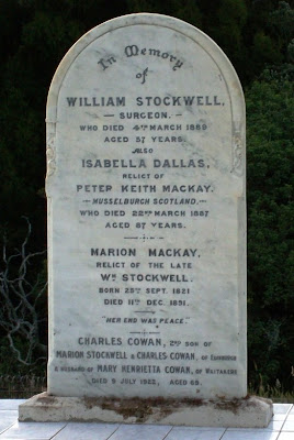
White tiles forever: the grave of Dr William Stockwell


The tiles, so I understand from members of the Friends of Waikumete Cemetery (as mentioned on the 30 October walk), are a recent upgrade. It is certainly a grave almost impossible to miss, now.

Here's what the Te Aroha News published as a obituary (from Auckland papers), 9 March 1889:
Another well known resident and also an old identity, has just passed over to the great majority, in the person of Dr. Wm. Stockwell, who died at his residence, Symonds-street, yesterday evening. Dr. Stockwell had been ailing for some considerable time previously, and three or four months prior to death he gave up his public practice, which was an extensive one. His complaint was heart disease, and he was attended by Drs. Mackellar, Philson, and Roberton, while other members of the medical profession paid the invalid every attention. The doctor was afflicted with heart disease, and it proved incurable. A change for the worse took place in his condition on Saturday morning last, and from that time till the end he sank gradually, retaining his consciousness till the last. Dr. Stockwell came to Auckland over twenty years ago, and soon established a good medical practice. Prior to arrival hero he had been an army surgeon and served in the Crimea, In Auckland he was for some time a member of the honorary medical staff of the Auckland Hospital, and he also acted as honorary surgeon to several benevolent institutions. The doctor also took an interest in farming, and he had one of the best-situated farms in the Waitakerei district. He passed away at the early age of 57 years. Dr. Stockwell was highly popular and respected by all who know him, and his death will be generally regretted.

Corban Mausoleum, Waikumete


It is little wonder that this has been photographed so often by visitors to the cemetery: it is a beautiful design. Hopefully, I'll be able to provide an update at some point once I find out the designer's name (I've asked West Auckland Historical Society what they know).

Update 31 March 2014: Thanks to Robin Wainwright at the Timespanner page on Facebook for the info, it turns out that the mausoleum was built in 1942, designed by Lewis Walker & Associates, Architects.


Sunday, November 7, 2010

Art on Parrs Cross Road


The gods smiled upon me today -- I was able to get to Parrs Cross Road in Oratia, looking for the apple-crate power box I've been trying to photograph for ages.  First up, though, along the walk from the bus stop: looks like the control box for lights to one of the Oratia Stream walkways off Parrs Cross.


The waves seem to me to have a Japanese tsunami art flavour to them.


Then -- I found the goal of the journey: the apple-crate box.


Even at the back, the wooden crate effect is maintained.


According to Auckland West, the artist is Robin Binsley.

Pukekohe's former fire brigade station


According to some online references to early newspapers in the Franklin area, this appears to date from 1930. The Pukekohe Volunteer Fire Brigade itself celebrated their 75th anniversary in 1986, so began in 1911. This must have been a great step up in facilities for them in the 1930s. Come the early 1980s, however, as has happened with so many fire services in the region, the old stations prove inadequate and are either demolished for new buildings on the same site or vacated. This one is the latter case. It apparently has been a restaurant recently.

I don't know what is expected to happen to the building in the future. I was just visiting Pukekohe for the day yesterday while attending a regional gathering for members of the NZ Federation of Historical Societies. When I can, I'll contact Franklin Historical Society (it's virtually right outside their rooms in the heart of Pukekohe) to see how things go.

Saturday, November 6, 2010

Pukekohe War Memorial

I've seen a few war memorials in my time -- but this one at Pukekohe, outside the War Memorial Hall,is probably the most poignantly beautiful yet.
 

The model for the bas relief soldier figure was W J (Bill) Short, a local Pukekohe man who served as a private according to members of the Franklin Historical Society (there is a William Short who served during World War I as a Lance-Corporal who was a Pukekohe butcher, according to the Cenotaph database. Whether that is the same man, I don't yet know.)


From NZ History online:

On 6 November 1921 Prime Minister William Massey unveiled the Pukekohe First World War memorial. The war memorial gates were situated on a plot of land donated by Mr William Roulston on the eastern side of the railway line. They included a column inset with a bas relief sculpture of a soldier, for which a local returned soldier, W.J. (Bill) Short, had reputedly served as the model. In April 1980 the memorial column was relocated from Roulston Park to the Pukekohe War Memorial Town Hall to enable the town's commemorative ceremonies to be held on a single site. During the 1980 Anzac Day ceremony, Mr Short laid a wreath on behalf of the First World War veterans present.

The death of Mrs Mareo


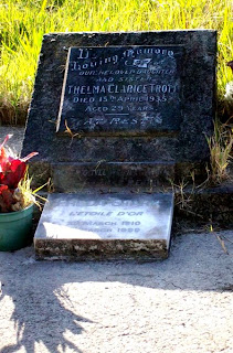
I went on a walk around the Waikumete Cemetery put on by the Friends of Waikumete last Saturday. I was asked by one of them why I was taking a lot of photographs (and answered, of course, that I was collecting stuff for a blog). One of the grave sites visited was that of Thelma Mareo, née Trott. You wouldn't know that by the gravestone, probably paid for by her mother after Thelma died of an overdose of veronal (and possibly also alcohol) in 1935. 

Veronal in those days was one of the early barbiturates, a "sleeping draught" as such medications were once termed. Around since the turn of the century, by 1935 the NZ Government recognised the danger of a depressant which could easily and lethally be misused, and so made it prescription-only, two weeks prior to Thelma Mareo's death. Her husband Eric, an out-of-work musician and composer who had worked at the St James Theatre, was using veronal, and stockpiled when it looked like casual supplies of the drug would be limited. Not a good move when your wife was a depressive.

She died from overdose, he went to trial (twice), was sentenced to death, later commuted, served 12 years, with more years beyond that on probation, and was finally clear of the legal system just before he died. The member of Friends of Waikumete who described the case last Saturday at the graveside said firmly that it couldn't have been suicide, that it had to be murder. (No one commits suicide with poison, I believe was whaat was said. I refuted that, by reminding those there of "Rough on Rats", a common method of suicide in the early years of last century. Further reading revealed that veronal, also, had been used in at least attempts at suicide before the Mareo case.) Eric Mareo's name wasn't even mentioned.

But a third option, on reading the online copy of the book The Trials of Eric Mareo (well worth a read) comes to mind. Thelma was a mother's girl, a depressive, "highly-strung" in the old parlance. Deeply fearful of ever being pregnant, she had a marriage of convenience with Mareo, more than anything else. Her love affair with Freda Stark was never truly outed during Mareo's trial -- to have done so, in the Crown's case, would have portrayed her as a sexual pervert in those times. Thelma drank, exhibited signs of depression, and perhaps took just a bit too much of both alcohol and the veronal in the days leading up to her death. Death by accidental overdose would be the third option, here.

When Freda Stark died, she was buried with Thelma, and her "L'Etoile D'or" plaque is on the grave site. The case that they are associated with, however, continues to fascinate.

Friday, November 5, 2010

End of Whale's Dairy


Back in 2001 when I was putting together Heart of the Whau, I took a photo of the 1920s dairy on St Georges Road here in Avondale. (I'm still looking for the colour original photo -- it was taken with a Kodak instamatic, my first ever camera.) The dairy's been through a number of name changes. From the book:
Originally built 1926-27 as the Whales Dairy, it became the Grosvenor c.1954 when the cinema also changed its name.It was known as O‘Brien‘s for a period during the 1980s and is now the Eftpos Dairy, after the “electronic-fund-transfer-at-point-of-sale” system of direct bankcard payment in the late 20th century to present.
Actually, it was known as both the Eftpos Dairy and Grosvenor Dairy (both names on the signs) right up until now. Now, of course, it no longer exists. These photos are from today.


Glad my mum isn't alive anymore. Her first job here in this country, arriving here as a woman looking after her mum and two sons on her own, was in that dairy in 1958. Then again, mum might just have put it down to changing times. That's what I'm doing. At the moment, I don't know what they're putting up in its place.

Overdoing the Square Edge, Palmerston North

Kiwi Nomad gave me the heads up on the repainting of Palmerston North's Square Edge building in her comment to my post on Repainting the Old -- with reference to Devonport's Victoria Theatre.

Take a look at the before ...


Kiwi Nomad wrote:
"We have a building here in Palmerston North -Square Edge- where a repainting job has maybe gone too far to the opposite extreme: it is very bright- all the facade details stand out- but there is no sense of context with surrounding buildings."
You're not kidding about the lack of sense of context, KN. That's just ... just ... words fail me, here. It's like a blue-and-red visual scream to me.