Tuesday, March 22, 2011

Christchurch city trams before the 'quake


Once again, some images from Bryan Blanchard, with his permission.
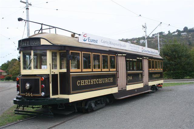
"... Christchurch in happier days. All in the Square, except 244 coming out into the street at the east end of the square."


Update 29 March 2011: More pre-quake photos from Bryan, taken at Cathedral Junction at the east end of the square, 7 February 2009.


 No. 178 (all above): " a boon tram, this class were introduced in 1921". Below, the ex-Melbourne W2 244.


 Tram 11 & trailer.


  Trailer & tram 178 in the distance.


Tram 178. Bryan's comment: "When I rode on the trams as a school boy up on holiday from Timaru - I rode
on trams like 178, painted green & yellow from Spreydon shopping shops into the square route numbers on trams were 14 to Spreydon & 16 to St Albans. Cost to the square from Spreydon was one penny.

"178 painted red, was a trial colour done in the 1930s on one or two."


Tram 244.

More Ferrymead trams

Bryan Blanchard has sent more images through, and said I can share them here (thanks again, Bryan, you're making my day!). Again, anyone is welcome to email me or add a comment with more info and corrections. While I love trams, I'm certainly not an expert (but I love to learn). Information below from Bryan's email.


Above and below.  Hills, tram 24 waiting restoration & ex-Dunedin, Mornington cable car 111 under restoration.


 Above and below. Ex-Invercargill Birney tram under restoration in the tram barn. A Birney image from Trams Down Under, and article from Stuff.co.nz on the No. 15.


 Above: The Beast - 5w with tram used in the city circle = W2 244 in the village. Below, on the Ferrymead tramway line.


 Below: Tram 152 & trailer 115 normally used on the city circle.


Also, here are Bryan's photos of the restoration work being undertaken to repair the tramlines after the recent earthquakes. Quoting from his email:

This is some of the work we were doing. We worked in with the Ferrymead gang - Cleaning the liquefaction sand of the track area  ( all fall stuff to shift )- straightening the sleepers in the track bed that had moved & rebalasting them & also with the shaking of the earthquake, a number of the sleepers needed the ballast repacked round them. The sleepers that had to be straighten, had to have the attaching screws, locking the plates that hold the rail line in place, loosened, straighten up & screws tighten up again, locking the attaching plates onto the railway line.   The works tram = THE BEAST, fleet No. 5w supplied the power/air needed to run the compressor to operate the air gun.


Update:

In answer to Sandy's question below about damage to Ferrymead from the Canterbury quakes, here's Bryan's response and another photo from his collection:


"Only real track damage I saw was on Ferrymead railways as seen on one of their sidings."

Trams at Ferrymead

I've just received permission from Bryan Blanchard, of the Pleasant Point Museum & Railway, to put his photos of trams at Ferrymead near Christchurch on the blog. Thanks, Bryan!

As always -- I welcome comments, additional information and corrections from tram enthusiasts. The more info, the better.

W2 224 - ex Melbourne, normally used in the city circle. There's a page on W2.224 which was part of the Melbourne fleet, not sure if it is the same tram, though.


(Above) Tram 152 & trailer - normally used in the city circle.

Above: 236, former Brisbane tram. According to this site:
This is Brisbane's two-bogie drop-centre tram, although it has much in common with Sydney's toastrack L/P trams. The first to be introduced was No. 231 ...At first, despite their weight, the trams were equipped only with hand brakes; air brakes were a late refinement. Later, air brakes were fitted to hand-braked models in reverse order. This process got as far as tram No. 276 before it stopped. 


Restored Christchurch No. 1.

The colours of Paynes Lane, Onehunga


Paynes Lane, Onehunga. According to the Auckland Central Library's streets database, named after Ronald Payne, who owned property taken for the lane, which conveniently leads straight to DressMart. I was heading through Onehunga yesterday, picking up some provisions for a day out at Archives New Zealand bent over old bits of paper -- when I spotted this:


This was spray painted in November last year, according to the Onehunga Community News. From that month's online edition:

The first of what is hoped to be a series of murals adorming the blank walls of Onehunga buildings is to be produced by the Cut Collective on the weekend of November 13th and 14th. Four or five artists will spend the weekend on scaffolding at the top of Paynes Lane, using spray paints to colourfully depict a variety of local imagery. Glen Armstrong of House of Travel provided the original inspiration and impetus behind the Cut Collective ...Glen says the mural will "reference the local community" and will be finished in plenty of time for Onehunga's first Santa Parade.


Yeoman Warder at Tower of London clips

While these clip links from YouTube (sent overnight by a friend in England) aren't anything to do with NZ history, I'm putting them up here anyway -- mainly because I reckon those in our local heritage field leading informative walks (including me!) should learn from this chap as to how to make history fun and informative at the same time.

Sure, he has the vast canvas of English history and the Tower of London to utilise but -- oh, go on. Watch the clips, and see for yourself.


Sunday, March 20, 2011

Titirangi, Fringe of Heaven


Marc Bonny is a friend of mine, a committed local historian, West Auckland Historical Society member and someone with a real love for the stories of Titirangi and West Auckland in general. His book, launched today, fills in yet another gap in our knowledge base as far as the history of our region is concerned. It was  also very nice to be mentioned in the acknowledgements as helping towards Titirangi, Fringe of Heaven (all I did was point the research team of Marc and well-known historian Bruce Harvey in the direction of the old deeds references at LINZ, and do some proofreading).

Check it out as an example of a community joining together and finding their voice to relate, to the future, the stories of how their particular part of our region came to be.

Titirangi's ever-shifting war memorial


Spotted the Titirangi War Memorial outside the local community centre/war memorial hall today. Thought -- Hey, how come I missed this when I photographed the special clay tiles last year? Did I? Maybe. But that cement work and the pavers at the rear look quite new. Plus, the war memorials page for this one at NZhistory.net, where the photos date from 1986 and 2009, show slightly different locations. Looks like, since 1965 when the memorial seems to have been shifted from its original spot on Memorial Hill (near Titirangi School, across the road from Lopdell House to the north), it has probably  been moved at least twice. Maybe three times. What on earth have the local authorities got against this lovely pillar? I'll leave it up to the locals to tell me more, should they come upon this post.

Anyway -- more images from today.


"Erected by H Atkinson to record the names of the men of Titirangi who left New Zealand to fight for the British Empire and the human race."


Massey West Auckland: A Palimpsest


In Titirangi's wonderful "Gone West" bookshop today, I found an unexpected treasure: Gillian Ruffle's Massey West Auckland: A "Palimpsest". There's the new word her book has introduced to my lexicon (if I remember it):
I called this a "Palimpsest", but this is really abusing the term! Literally a palimpsest is an old manuscript that has been re-used for writing new messages after erasing earlier ones. Scholars have learnt how to decipher old messages that have been "written over" in this way, and I thought that I would like to view Massey in a similar fashion.
And then there is the way she has organised the book -- anchoring her research on her own property in Massey, she has gone back in time, to 1850, 1900, 1950 and 2000 to determine who would have owned the land, what it may have looked like, how to get there at each period, etc. Along the way, the book is festooned with maps, diagrams, tables of Crown Grantees and other relevant names and details.

I think I was very lucky to get my hands on this today. The only copy in the entirity of the 55 library system of Auckland Council is a reference only copy at Henderson Library. I couldn't find it at the National Library catalogue, and nothing at the Auckland War Memorial Museum Library. I certainly haven't seen this before.

So, if this has had limited publication, it's a real shame -- Massey West Auckland fills a gap in our knowledge of that part of Auckland, and is a real resource when it comes to research into the land ownership patterns and history of the area. Gillian Ruffles says this is a "work in progress". I hope someone comes along with funding, if she's still interested at this point, to continue such great work.

If you see the book, and can buy or borrow it, do so. Definitely worth a look.

National topographic maps online

Peter Hjorring emailed this link to Land Information New Zealand's collection of downloadable topographic maps.

31 regions covered, including the Chathams.

Thanks, Peter!

Saturday, March 19, 2011

Tales from the Crypt


I've finally been able to get my hands on a copy of Matthew Gray's book Tales from the Crypt today (they were being sold today at the 125th anniversary commemoration function at Waikumete Cemetery). Based on his series of articles published weekly in the Western Leader, I found the book to be better than expected. Then again, the old trad in local history writing -- if you want folks to like the book, put their name in it -- probably has some effect on my judgement with regards to this publication. Seeing that Matthew Gray not only cited A Doctor in the Whau, he also cited Timespanner itself (two instances, the Castles of Waterview and Wesley Neal Spragg's memorial in the George Maxwell Memorial Cemetery). On top of that, he's also raised the subject of Clara Bethell's relocated headstone at MOTAT.

What I liked about the book is that he has taken time to source and reproduce photos of the deceased where possible, not just their headstones -- and has divided the book into sections, based on the cemeteries:

Bush Graves
George Maxwell Memorial Cemetery (Avondale)
Hobsonville Cemetery
Oratia Cemetery
St Ninian's Churchyard (Avondale -- actually, Matthew, this is a cemetery as well)
Swanson Cemetery
and Waikumete Cemetery

There are some errors (there are errors in every local history book published, somewhere, if you nit-pick enough), but -- I'm delighted I made the investment, finally got to briefly meet Matthew today, and ... yes, okay, okay, I'm quite thrilled to see this here blog, my pet project, cited as a resource. 

Heh. Thanks, Matthew. I enjoy your work, too.